Miyerkules, Mayo 30, 2012

canadian rockies


During our recent trip to the Canandian Rockies I focused on gaining a more thorough understanding of the biophyscial charateristics which may be used to define the region.
Not only was I impressed by the relative 'wild' character which still dominates throughout the area, but I began to understand how quickly ecological conditions can change in a
mountainous region such as the Canadian Rockies. The result of the amount of ecological diversity within the region, most notable as one moves east-west, or changes ones elevation,
is that the amount of biological diversity in such a narrow region, and at such a northern latitute, is quite impressive.

The natural history of interior southwestern Canada may be defined as a richly diverse community of plants and animals existing within extreme, and
sometimes dynamic, environmental conditions. The geological foundation on which the biota of this region exist, has been a constant and active influence
in the development of patterns and processes which currently appear throughout the land. Due to the relatively close proximity of the northern Rockies
to the Pacific Ocean, the regional climate patterns are largely influenced by Pacific weather. However, the region as a whole is not easily defined by any
one type of weather pattern or climatic regime. This is due largely to the extreme relief of the peaks that comprise the heart of the northern Rockies.
Weather can change rapidly as eastward moving air currents cool as they are forced rapidly up west-facing slopes, then just as quickly, drop once over the
crest of the Rockies onto the flat Alberta plains. With the variable climate and geology has come a stratification of life zones within the mountains. It is this
type of extreme variabililty which is the essence of the northern Rockies.

The Canadian Rockies are defined by the following parameters. They comprise a mountain range which extends from the Interior Plains on the
east to the Rocky Mountain Trench on the west, and from the Liard River in northern British Columbia to the southern boundary of Glacier National
Park, Montana. The portion of the region which our course studied, and completely circumnavigated, extended the northern boundary only to the border
of Banff and Jasper Provincial Parks. In addition we entered northern Montana to the east of Glacier rather than circling around the southern end of it.
The region is remarkable in that it is such a narrow and long chain of mountains with a high degree of natural integrity. Four areas of general interest can
be used to describe the region: geology, topography, climate, ecology.


Geology

The geology of the northern Rockies can be generally described as sedimentary rock up to 1.5 billion years old,
deposited mostly below sea level, over the years has been bent, broken and piled up. The mountain-building of the
Rockies began about 140 million years ago, tapering off around 45 million years ago. We approached the Canadian
Rockies via the Columbia River Basin, a wide,glacially-carved valley, with mountain ranges on either side. As one
moves north the continental plate forces that shaped the region become more and more obvious. The exposed basalt
and shale sedimentary formations crown the jagged peaks. The formation of the Canadian Rockies is considered to be
relatively young on a geological time scale and while the weathering of the mountain tops is extreme, the mountains
still largely reflect the character of their origin.


Topography

Ridges trending northwest/southeast are separated by parallel U-shaped valleys. The majority of the major rivers in the region flow through valleys
extending from the southwest to the northeast. On the western flanks of the Canadian Rockies many smaller rivers feed into the Columbia river which
flows to the south to Washington and eventually west to the Pacific Ocean. Erosion from continued glacial activity is predominant throughout the range
and glaciers up to 300 square kilometers still exist along the crest of the range.


Climate

The average mean annual temperature for all public weather stations on the valley floors is 2.6 degrees Celsius or approximately 23 degrees Fahrenheit.
The mean annual precipitation is 571 mm. As stated above the weather is strongly influenced by the extreme topography of the region. The eastern slope
is noticeably cooler and drier than the western slope,and strong chinook winds have the potential to rapidly warm the eastern slope in the winter.


Ecology

The stratification of the plant and animal communities in the Rockies is easily correlated to elevational zones. The two major, widespread life zones, are
the subalpine and the alpine. Below these zones exist a multitude of river valley and montane forest zones. Limestone-rich areas and the quartzite rich
areas have distinctive biological features. A great deal of the wilderness within the region still maintains a high degree of ecological integrity. Nearly all of
the native species are present, though only a fraction of the number which existed in the region only two hundred years ago. The present situation is one
in which many ecological systems of the region are experiencing stress, both from natural resource extractive industry, and development pressures.


Lunes, Mayo 28, 2012

Sahara Desert


The Sahara is considered as the largest hot desert in the world. It is also the second biggest desert in the world - next only to the icy desert of Antarctica. The Sahara sustained several civilizations that thrived in its arid environment. Up to now, amidst its vast, dry and hot façade, it is very popular, especially in the field of research.

The Sahara is considered as the biggest hot desert in the world. It is also the second biggest desert in the world, following Antarctica. With an area of more than 9,000,000 sq km, it is estimated as able to cover a majority of the northern part of Africa. This would include some areas that stretch from the infamous Red Sea, portions of the vast Mediterranean coasts, and the Atlantic Ocean's beautiful outskirts. The Sahara is said to be similar to the size of continental US and very much larger as compared to Australia.

Moreover, when it comes to the history of the Sahara, it is as intermittent as it is three million years ago. With regards to its name, Sahara is an Arabic word for "Sahra'" which means "desert". This means that calling it "Sahara Desert" is being redundant.

Hence, the history of the Sahara is as interesting as it sounds. Around 6000 BC, some pre-dynastic Egyptians who were in Egypt's southwestern corner were herding some cattle and were constructing some large buildings. At this time, the subsistence in permanent and organized settlements predominantly centered on animal agriculture and cereal. Animal agriculture would include goats, cattle, sheep and pigs. Metal objects are already replacing stone objects. Weaving, pottery and Tanning of certain animal skins were also common at this time. Reports also indicate that the Al Fayyum's temporary or seasonal occupation pertaining to food gathering, hunting and fishing were practiced.

Furthermore, the pre-dynastic Egyptians had scrapers, knives and arrowheads already. Their burial items included jewelry, pottery, hunting and farming equipment, along with assorted foods like fruit and dried meat. Their dead were buried in such a manner that they faced due west.

Around 3400 BC, the Sahara is noted to be dry as compared to its situation today. Due to this, it was very much impenetrable to the earlier Egyptians or to any human being for that matter. The only settlements were found scattered along its oasis. Even so, only little commerce and trade was present throughout this desert. The only exception for this would be along the Nile Valley. However, there are several cataracts of this river that was impassable. This is why trade as well as boat contact was very difficult.

Thus, by the Neolithic era, prior to the desertification onset, the central portion of the famous Sahara had a rich environment that supported a huge population that ranged across the barren desert that it is now. A good example is what they called Wadi el-Qa'ab.

Around the fifth millennium BC, people inhabiting the area called Nubia now were already full participants of the so-called "agricultural revolution". They lived and settled with a lifestyle that domesticated animals and grew plants. Hey were called the early Nubians.

Saharan herdsmen and cattle rock art that were found earlier in the famous Sahara suggested that there were cattle cult, similar to the ones found in Sudan, were prevalent at that time. This is also like the current pastoral societies of Africa. With regards to the megaliths that were found in Nabta Playa, they were considered as overt examples of the first recognized Archaeoastronomy devices in the world. This predated the Stonehenge by a few thousand years. Thus, as per noted observations in Nabta Playa, the complexity and expression of various levels of the society's authority at that time formed their structure's basis for both Nabta's Neolithic Society and Egypt's Old Kingdom.

Later on, the Phoenicians or Phoenicia's residents who were around between 1200 up to 800 BC made a so-called "Confederation of Kingdoms" all over the Sahara and even up to Egypt. Generally, they settled within the regarded Mediterranean coast and the Sahara, This is also amongst the Ancient Libyan people, who were noted as the Sahara and North Africa's Berber Language ancestors. This is also along with Central Sahara's Tuareg community. Other adaptations of North Africa's ancient Libyans were the recorded Phoenician alphabet and the Tifinagh, which is still being used these days by Central Sahara's "Tuareg camel herders" that still speak the Berber language.

Then, around 633 BC up to 530 BC, the renowned "Hanno the Navigator" was noted to have either reinforced or established the Western Sahara's Phoenician colonies. However, all the ancient remains somehow vanished without any recorded trace whatsoever.

Thus, around 500 BC, the Greek influence arrived. This is with the spread of Greek traders along the desert's eastern coast and consequently establishing their trading colonies within the coast of the Red Sea. It is indicated that the Carthaginians were the ones who explored the Sahara's Atlantic coast. However, with a lack for markets and disturbing water turbulences, no extensive presence thrived farther than the modern Morocco we see now. Then again, there were already indicated centralized states that surrounded the Sahara through its northern and eastern portions but they remained beyond the states' control. For those living by the desert's edge, their constant concern at that time were raids made by the nomadic Berber natives.

Thus, after the Phoenicians, another urban civilization known as he Garamantes arose in the Sahara's central area. This is along a valley they currently call Wadi al-Ajal situated in Libya's Fazzan region. The Garamantes was noted to achieve a stronger kind of development via digging some tunnels farther into the region's mountains. This is in order to flank the valley and tap some fossil water they can bring to the fields they made. As the Garamantes became populous and strong, they even conquered their neighbors and captured several slaves. These slaves were the ones who worked on extending their tunnels.

This is one reason why the early Romans and Greek regarded the Garamantes as "uncivilized nomads". Even so, they continued their trade with the Garamantes. In fact, along Garama's Galamantes capital, a Roman type of bath was discovered by Archaeologists. Aside from this, eight major towns as well as various other significant settlements were found along the regarded Garamantes territory. As per reports, the civilization of the Garamantes eventually collapsed due to the fact that they already depleted all the available water within the so-called aquifers. With this, they could not sustain the task of extending their tunnels in order to go further and deeper into their mountains.

This is how the Sahara sustained several civilizations that thrived in its arid environment. Up to now, amidst its vast, dry and hot façade, it is very popular, especially in the field of research, where in, it is believed that valuable ancient artifacts, relics and even fossils of the ancient civilizations is hidden there, somewhere.

Biyernes, Mayo 25, 2012

Machu Picchu, Peru


Machu Picchu ("old mountain" in Quechua, the ancient language of the Incas) nestles on top of a mountain saddle high above the Urubamba River in the middle of the cloud forest. It was both a center of worship and astronomic observatory as well as the private retreat of the family of Inca ruler Pachacútec. It is split into two major areas: the agricultural zone, made up of terracing and food storehouses; and the urban zone, featuring the sacred sector, with temples, squares and royal tombs which have been carved to an extraordinary degree of perfection. The stone staircases and canals are found throughout this unique archaeological site. Over the citadel looms Huayna Picchu ("young mountain" in Quechua), which can be climbed up a steep stone-paved trail
The Machu Picchu historic sanctuary, and particularly the forests that line both banks of the Urubamba River, below the citadel of Machu Picchu itself, are home to the habitats of an enormous variety of bird species, calculated at more than 400, such as the cock-of-the-rocks (Rupicola Peruviana), considered Peru's national bird. The area also features brightly-colored orchids and tree-born ferns, considered treasures of the sanctuary.
Located in the department of Cuzco, covering an area of 32,592 hectares, the Machu Picchu Historic Sanctuary protects unique species of flora and fauna, as well as featuring some breath-taking landscapes and preserving the archaeological sites to be found here. Much of the beauty and enchantment of Machu Picchu, Peru's premier tourist attraction, is due to its spectacular natural surroundings: the cloud forest region of this historic sanctuary.

Machu Picchu is home to some striking species, such as the cock-of-the-rocks (Peru's national bird) and the spectacled bear, the only bear species in South America. The area is also inhabited by the rare dwarf deer called sachacabra and the Huemal deer, plus more than 300 bird species. The area boasts a large variety of flora species, with some 200 species of orchids registered here to date.

Towering over the area is Mount Salkantay (6,271 meters), the highest mountain in the Cordillera Vilcanota range, worshipped by the locals as an apu mountain spirit. Machu Picchu combines a spectacular natural setting with the attraction of the world's most famous pre-Hispanic sites

The ancient Inca citadel of Machu Picchu is the star attraction of Cuzco. Discovered in 1911 by US explorer Hiram Bingham, the citadel is deemed one of the world's finest examples of landscape architecture.

Miyerkules, Mayo 23, 2012

Raja Ampat, Indonesia


This small area in Indonesia has the richest coral reef life in the world. Kind of the coral reef epicenter of the planet. It's expected to soon become the first marine Unesco World Heritage Site. Unfortunately, the underwater housing for my camera had a little problem with leakage... so I didn't have the opportunity to do any underwater photography.
Apart from the reefs, this area also has some of the most stunning top-side views in the world; lime stone islands that reminds you of, but are even more dramatic than, the famous Rock Islands of Palau; big cathedral-like caves inside the islands; quiet lagoons with crystal white sand and water in every shade of blue and green; bird life such as the Birds of Paradise that brought Alfred Russel Wallace to this region over a century ago; the most stunning sunsets you'll ever see; and - almost no tourists...
I really liked this place.

One reason why I decided to prepare this site was that you won't find any information on this area in standard Indonesian travel guide books such as Lonely Planet. The Raja Ampats, located west of the Birds Head Peninsula, are administratively part of Papua Barat/Iran Jaya, but they are very different from the rest of west Papua, which the travel guides are focused on. Geographically and when it comes to nature, history and culture, the Ampats are in many ways closer to Moluku.
Raja Ampat* means "the four 'kings'", a name dating back to the 15th century, when the Sultanate of Tidore - one of the muslim sultanates in the original Maluku west of Halmahera - appointed four local "rajas" in Misool, Salawati, Batanta and Waigeo.

Even earlier, Seramese traders from small islands off the eastern tip of Seram had established trade settlements, sosolot, throughout the region, exchanging cloth, beads, and other products from western Indonesia for trepang, plumes, forest products and slaves from Papua. There where also a strong ties to the island of Biak east of the Bird's Head Peninsula.

Rock paintings found in caves in Misool and in on the west coast of the Birds Head, as well as bronze artifacts, show that trade with other parts of Asia was already established 2 - 3 000 years ago.

Going further back, it should be noted that just 10 000 years ago, at the end of the last ice age, most of what is currently sea in this area was still land, roughly corresponding to the lighter blue parts in the Raja Ampat Map. This means that most of the early coastal settlements in this area are now submerged, and will require underwater archeology to be found and explored

Lunes, Mayo 21, 2012

Pyramids of Egypt


Egyptian pyramids are great monument of a great civilization that was born seven thousand years ago. The ancient Egyptians built more than 90 royal pyramids, from about 2630 BC until about 1530 BC. During that time, the pyramid shape evolved from a series of stepped terraces to sloped pyramidal shape.
When were Egyptian pyramids built?
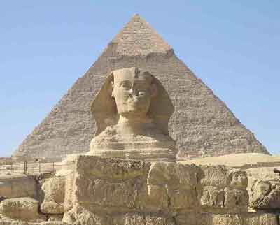
The first pyramid, the Step Pyramid at Saqqara, was constructed during the reign of King Djoser (Zoser) (2630 BC-2611 BC). The largest pyramid in Egypt is the one built for King Khufu, in Giza. Khufu’s pyramid, known as the Great Pyramid, is the only one of the Seven Wonders of the World that still exists.
Why were Egyptian pyramids built?
Egyptian pyramids were originally built to serve as tombs for kings and queens. After a ruler died, his or her body was carefully treated and wrapped to preserve it as a mummy. According to ancient Egyptian belief, the pyramid, where the mummy was placed, provided a place for the king to pass into the afterlife. In temples nearby, priests performed rituals to nourish the dead monarch’s spirit, which was believed to stay with the body after death. In the Old Kingdom Egyptian artists carved hieroglyphs on the walls of the burial chamber, designed to safeguard the dead monarch’s passage into the afterlife. These hieroglyphic writings, which include hymns, magical spells, instructions on how to act in front of the gods, and other pieces of useful knowledge, are known as the Pyramid Texts.
How were the Pyramids built?
There are many theories of how the pyramids were built but no body knows for sure the process ancient Egyptians followed to build the pyramids. One theory suggests that ramps were built to drag the blocks of building stones on sledges to the top. There are some evidence that this theory might be close to the truth as some parts of the mentioned ramps were found near building sites. These ramps were made of bricks and earth rubble and they were strong enough to carry the huge blocks used to build the pyramids.
Stones used in the construction process were quarried from remote or local quarries where they were either transported using wooden sleds as the wheel had not yet existed and even it had it wouldn't be of much use due to the heavy weight of the blocks.
Whatever the means of building the pyramids it remains a fact that Egyptians did all the work and there was no magic or aliens involved in the process as some naive people might think.
What is the internal layout of the pyramids?
Pyramids internal layout changed over time, but the entrance was typically in the center of the north face. From here a passage ran downward, sometimes leveling out, to the king’s burial chamber, which ideally was located directly underneath the pyramid’s center point. Sometimes, in addition to the burial chamber, there were storage chambers within the pyramid to keep objects used in burial rituals as well as items for the deceased to use in the afterlife. Some of these items were valuable, and in later years people robbed many of the pyramids and stole the objects.
A Pyramid was never built alone in the desert. Instead, it was in the middle of temples and smaller pyramids forming a complex of pyramid temples.
Most pyramid complexes had satellite pyramids and queens’ pyramids. The satellite pyramids were too small to serve as burial places, and their purpose remains mysterious. They may have contained statues representing the king’s ka, an aspect of his spirit. The queens’ pyramids were simpler, smaller versions of the kings’, sometimes with small temples all their own. They were intended for the burial of a king’s principal wives.


Egyptian pyramid of Khufu

The largest Pyramid, King Khufu’s, is often called the Great Pyramid. It lies in the desert west of Giza, accompanied by the pyramids of Khafre and Menkaure (Khufu’s son and grandson). The Great Pyramid was built during Khufu’s reign (2551 bc-2528 BC). A question was commonly asked: How long did it take to build the Great Pyramid? The answer of this question is not confirmed but it probably took twenty to thirty years to complete the pyramid.
Characteristics of the Great Pyramid of Khufu
The base of the Great Pyramid forms a nearly perfect square, with only a 19-cm (about 7.5-in) difference between its longest and shortest sides, out of a total length of about 230 m (756 ft). This huge square is also almost exactly level. When newly completed, the Great Pyramid rose 146.7 m (481.4 ft)—nearly 50 stories high. Researchers estimate that 2.3 million blocks were used to build the Great Pyramid, with an average weight of about 2.5 metric tons per block. The largest block weighs as much as 15 metric tons.
In building Khufu’s pyramid, the architects used techniques developed by earlier pyramid builders. They selected a site at Giza on a relatively flat area of bedrock not sand which provided a stable foundation. After carefully surveying the site and laying down the first level of stones, they constructed the Great Pyramid in horizontal levels, one on top of the other.
Most of the stone for the interior of the Great Pyramid was quarried immediately to the south of the construction site. The smooth exterior of the pyramid was made of a fine grade of white limestone that was quarried across the Nile. These exterior blocks had to be carefully cut, transported by river barge to Giza, and dragged up ramps to the construction site. Only a few exterior blocks remain in place at the bottom of the Great Pyramid. During the Middle Ages (5th century to 15th century) people took the rest away for building projects in the city of Cairo.
To ensure that the pyramid remained symmetrical, the exterior casing stones all had to be equal in height and width. Workers marked all the blocks to indicate the angle of the pyramid wall and trimmed the surfaces carefully so that the blocks fit together. During construction the outer surface of the stone was left unfinished; excess stone was removed later.
As the Great Pyramid rose, the workers built large ramps to drag their materials up the sides of the structure. The exact form of these ramps is not known, but scholars believe that they were probably built wrapping around the pyramid as they rose. These ramps were probably made of desert clay mixed with water and bonded with limestone debris left over from the construction work.
When the workers had completed the pyramid and installed the pyramidion, or cap stone, ramps still covered the surface of the pyramid. As the workers dismantled the ramps from the top down, they slowly exposed the pyramid’s stone surface, which stonemasons smoothed and polished. When the ramp was gone, the pyramid was displayed in its full majesty
.

Khufu Pyramid from inside

The interior of the Great Pyramid is complex, with a series of passages leading to several rooms. The most important room is the King’s Chamber, the room in which Khufu’s body was placed during his funeral. In this room the priests left items that Khufu, like all Egyptians, would need for the afterlife. Although the builders tried to block passages and doors when they left the pyramid after the king’s funeral, tomb robbers did eventually take everything of value.
The entrance to the Great Pyramid was set 17 m (55 ft) above ground level. It was intended to be used only once, during Khufu’s funeral, when special scaffolding was erected. Once the scaffolding was dismantled, the entrance’s height served as a security measure against tomb robbers. The entrance leads to the Descending Passage, which runs down through the pyramid into bedrock beneath the pyramid and levels out until it reaches the Subterranean Chamber. About 18 m (60 ft) from the pyramid entrance, before entering the bedrock, the Descending Passage intersects another corridor, called the Ascending Passage, now sealed with three large granite blocks.
The Ascending Passage runs upward for about 39 m (129 ft), until it levels out and enters the so-called Queen’s Chamber. Early Arab explorers of the Great Pyramid gave it this name in the mistaken belief that the queen was buried here. Instead, it most probably held a statue of the king that represented his ka, a form of his spirit. The walls of the unfinished Queen’s Chamber grow closer as they rise and meet at a single point at the ceiling. This form results from each level of stones in the walls projecting slightly outward from the level beneath it, an arrangement called corbeling.
Where the Ascending Passage levels off horizontally and runs toward the Queen’s Chamber, it also intersects with one end of the Grand Gallery, a large, corbeled passageway 47 m (153 ft) long and 8.5 m (28 ft) high. The Grand Gallery most probably held some of the large stones that were used to plug passages after the king’s funeral. In the western wall at the point where the Ascending Passage and the Grand Gallery meet, there is an opening to a tunnel that winds its way down through the core of the pyramid and the bedrock to meet the Descending Passage near the Subterranean Chamber. It probably provided air to the workers carving out the Subterranean Chamber.
At the upper end of the Grand Gallery, another level corridor runs south into the King’s Chamber, a simple, rectangular room faced entirely with red granite. All that remains in the room now is a granite sarcophagus in which King Khufu was buried, near the western wall. About 1 m (3 ft) above the floor, near the center of the northern and southern walls of the King’s Chamber, are openings to shafts that run upward through the pyramid to the exterior of the pyramid. The exact purpose of these shafts is not known. Similar shafts lead out from the Queen’s Chamber but are blocked after 65 m (213 ft) and never reach the exterior of the pyramid.

Development of Pyramids in Ancient Egypt


Djoser step pyramid in Saqqara

King Snefru pyramid in Meydum

The Egyptian pyramids developed from royal tombs of the earliest periods of Egyptian history. In the 1st and 2nd dynasties (2920 bc-2770 bc and 2770 bc-2649 bc), kings were buried at the city of Abydos in graves topped with a pile of clean sand inside low-lying brick walls. By the 3rd Dynasty (2649 bc-2575 bc), kings were being buried underneath large mud brick rectangles called mastabas, from the Arabic word meaning “bench.”

King Djoser, who reigned from 2630 bc to 2611 bc, built a more elaborate royal tomb known as the Step Pyramid at ?aqq?rah. This tomb started out as a mastaba, but its architect, Imhotep, first expanded the mastaba then topped it with successively smaller mastabas. In the end, Djoser’s tomb looked like a rectangular wedding cake with six layers.
The Step Pyramid and later pyramids of the 3rd Dynasty were constructed of small, almost brick-sized stones that were laid in vertical courses and inward-leaning to create the sloped sides.

King Snefru pyramid in Meydum

King Sneferu, the father of Khufu, built the initial true pyramids, developing the new technique during construction. The earliest true pyramid, at the town of Maydom, began as a step pyramid with inward-leaning walls and eight levels. After working on the structure for 14 years, Sneferu moved his burial ground north to Dashur for unknown reasons, and construction began on another pyramid. This one, too, was made of stone blocks that leaned inward. The architects had designed it with an angle of 60 degrees (to the ground), but as the pyramid rose, it started to sink because of the weight and angle of the stones. To solve this problem, the builders put up an outer supporting wall, giving the half-finished pyramid a shallower angle of 55 degrees. After this, the architects finished the upper portion of the pyramid off with a slope of only 43 degrees. This shift in angle from 55 to 43 degrees gives this pyramid its name—the Bent Pyramid.
During construction of the Bent Pyramid, the architects made a discovery: On the upper portion, instead of leaning the stones inward, they laid down horizontal layers of larger stone blocks. With the new technique, the pyramid shape resulted because each level was slightly smaller than the one it lay upon. The new technique was then used to construct another giant pyramid for Sneferu, now called the North Pyramid, located about 1.6 km (1 mi) north of the Bent Pyramid. It proved so successful that Sneferu returned to Maydom, while construction was still in progress on the two Dashur pyramids, and refined the Maydom pyramid by adding an outer level constructed with the new approach.
All Egyptian pyramid builders of the 4th Dynasty (2575 BC-2467 BC), including the builders of the Great Pyramid at Giza, used Sneferu’s new technique. Over the course of the 5th Dynasty (2465 BC-2323 BC), however, the quality of the royal pyramids declined. The cores were made of smaller blocks of stone, laid more irregularly. By the end of the Old Kingdom around 2134 BC, the pyramids had a core of shoddy masonry and debris covered with a veneer of fine limestone.
After a chaotic period in Egyptian history called the First Intermediate Period (2134 BC-2040 BC), Egyptian kings chose to be buried in pyramids at their new capital city near modern Lisht. These pyramids of the Middle Kingdom resemble those of the late Old Kingdom, being loosely constructed of rough stones, debris, and mud-brick, and coated with fine limestone. However, the associated temples were much larger than those of the Old Kingdom.
Egyptian pyramids built early on in the Middle Kingdom were entered through an opening cut into the center of the north face, from which a simple passage descended. By the reign of Senwosret II (1897 BC-1878 BC), builders altered this simple and predictable arrangement. At his pyramid at Illahun the entrance led to a system of shafts on the south side of the pyramid and a passageway that circled the burial chamber before opening into it. During the rest of the Middle Kingdom in Egypt, royal pyramids became increasingly complicated in plan, presumably to foil the intentions of tomb robbers.
In the New Kingdom (1550 BC -1070 BC), kings were no longer buried in pyramids. The site of royal tombs had shifted to the Valley of the Kings near modern Luxor. But private citizens used small pyramids for tombs that were barely higher and wider than the entrances to them.
The pyramids of Egypt have long captivated people’s imaginations. The Greek historian Herodotus described his visit to Egypt and its pyramids in the middle of the 5th century BC, and later Greek and Roman travelers admired and climbed the Great Pyramid. The Roman writer Pliny the Elder, who lived in the 1st century AD, told of local Egyptians who would help tourists in their ascents.
Today Pyramids stand witness to a great civilization once existed several thousands years ago challenging time to stay in place maybe for other several thousands years to come.

Linggo, Mayo 20, 2012

Pamukkale mineral terraces, Turkey


Pamukkale (Hierapolis) is both, a magical and spectacular natural site, unique in the world and with its ancient ruins it is perhaps the most attractive spot for tourists.

Hierapolis was named after Hiera, the wife of Telephos, founder of Pergamum in mythology. 

As you approach the site of Pamukkale / Hierapolis from Denizli, (only 20 km) a long white smudge along the hills to


Pamukkale - hot springs and spetacular scenery

the north suggests a landslide or open cast mine. Getting closer, this resolves into the edge of a plateau, more than 100m higher than the level of the river valley and absolutely smothered in white travertine terraces. 

Pamukkale is one of the most extraordinary natural wonders in Turkey. Dozens of coaches daily make the long excursion, (three hours drive from Bodrum), Marmaris or Kusadasi. Stay over-night if you can to enjoy its tranquillity early in the morning or in the evening.

The big attraction is a vast white cliff side with scallop-shaped basins of water and frozen waterfalls. It looks as if it's made out of snow or cloud or balls of cotton. The Turks have dubbed this geological fairyland Pamukkale (cottoncastle), from pamuk for cotton and kale for castle.


Pamukkale Thermal Pool

For thousands of years a deep underground spring has been pouring out streams of hot, mineral-saturated water. As it has flowed down the mountainside the steaming water has hollowed enormous circular basins in the earth, and the water's rich mineral content has coated them in a smooth layer of dazzlingly-white calcareous rock. To the ancients such beauty could only mean that the place was sacred to the gods. Built near the natural hot springs, the grand city of Hierapolis attracted a steady stream of pilgrims, who came to bathe in the curative waters. Pamukkale is located 250 km from Izmir and 20 km from Denizli. Most of the hotels are in Karahayit, 5 Ian north of Pamukkale. The water is 42-56 C, the pH is 5.98, similar to Pamukkale, but the water has more iron content. 
Capacity 
The Pamukkale hot springs flow at a rate of 400 liters per second. The various facilities can accommodate about 6,000 people a day which amounts to 600 liters of water per person per day. 


Pamukkale Travertines
Physio-chemical Characteristics and indications 
The mineral-rich Pamukkale hot spring waters are high in calcium, magnesium sulfate and bicarbonate. They also contain carbon dioxide and have a radioactive content of 1,537 picokuri/liter (or 56 bekerel/liter). Water temperature is 36 to 38 C with a pH of 6. Total mineral content is 2,430 mg/It. The waters are used for drinking and bathing. They are recommended for the treatment of rheumatic, dermatological and gynecological diseases, neurological and physical exhaustion, digestive maladies and nutritional disorders. 

Treatments and accommodations
Throughout history, Pamukkale has been a famous spa, with baths and open pools set into the snow-white cliffs. Bath treatments take place in natural pools, which developed around the main hot springs. Hot mineral water spas have been opened at a number of new and very comfortable hotels in the area.

Huwebes, Mayo 17, 2012

Cancun Mexico


Summary: The far East of the Peninsula of Yucatán, to the South of the Mexican Republic is surrounded by the Caribbean sea and is known as the Mayan Coast, given this pre-Hispanic civilisation's influence all across the area, from Punta Brava to Punta Allen. The north side of the coast boasts an amazing tourist infrastructure and impressive development.

The far East of the Peninsula of Yucatán, to the South of the Mexican Republic is surrounded by the Caribbean sea and is known as the Mayan Coast, given this pre-Hispanic civilisation's influence all across the area, from Punta Brava to Punta Allen. The north side of the coast boasts an amazing tourist infrastructure and impressive development.


The south, on the other hand, is home to many different small picturesque villages surrounded by unspoilt beaches, where the Gran Arrecife Maya is to be found, the second largest reef in the world. The south is famous for its forest, with exotic vegetation and great variety of animal species. It is also famous for its underground rivers, caves and deep-sea caverns. 
The civilisation which originally inhabited this peninsula was the Mayan civilisation, very advanced as regards the sciences of the Earth and skies, famous for the precision of their calculations and the complexity of their religious rites. In the post-classical period, from the year 1,000 to approximately the year 1,500, the peninsula was an important commercial and religious centre. Tulum was then a fortress on the Caribbean shores. Playa del Carmen was then known as Xaman-Ha, and what is now Xcaret was known as Puerto Pole. The most important city was Cobá, with a population of 50,000 inhabitants.
With the arrival of the Spaniards in 1519, the main Mayan cities, such as Chichen Itza and Uxmalhad already been abandoned, what with the wars and conquests of other peoples, the harsh climate and the dangers of the forest, together with the frequent threat of hurricanes, which had caused the civilisation almost to disappear. Xel-Ha went down in history as the first European settlement. However, during the Colonial period the growth of the population was not made easy, given the proximity of the open sea and the pirate attacks. These attacks made it difficult to reach the land, and even when that obstacle was overcome, the forest posed many more difficulties and dangers. This is the main reason why the peninsula was unknown for so long.
In 1967 the Mexican Government recognised the importance of the tourist industry as an active ingredient of the country's economy, and Cancun was one of the places to become a firm candidate for foreign investment and the development of a hotel and entertainment infrastructure, given that its natural beauty was an obvious temptation for any traveller. The first hotels that were built in the 70s were the Palacio Maya and Club Med, both of which developed a great reputation.
Cancun is still an important tourist destination today, and up until the 90s many new hotels were built, as well as American-style shopping malls and all the entertainment facilities it now has to offer.
Cancun is now divided into three areas: Ciudad de Cancun, with a population of 300,000 and a simple and straightforward infrastructure; the ecological reserve, with its incredible lakes, forests and mangrove marshland, and the Zona Hotelera, an island where most of the hotels and shopping malls are to be found. There are two new projects under development, including a tourist sea resort called Puerto Cancun and another project known as Malecón Cancun, covering some 170 acres of land.
Cancun has more than 25,000 hotel rooms to offer, 200 restaurants and several hundred shops. There are roads leading to the forest, making it easy to get to in most cases.
Cancun has many different faces which come together to offer the natural beauty of what is truly a Caribbean paradise, the forest, and the comfort of five star, Gran Turismo and Categoría especial hotels, all in the setting of what was one of the most advanced and intelligent civilisations in the old world.